Saturday, November 28, 2020

Cash Lake Loop, National Wildlife Refuge Center, 11/28/20


Found the trailhead for a 3.1-mile hike recommended by our newest hiking book Hiking Maryland and Delaware, only to find the first section of the loop closed off due to hunting in the area. 

Still managed a 2.2-mile loop via Laurel and Valley trails to Goose Pond and Cash Lake, a stroll really rather than a hike! 

So as not to interfere with wildlife research, Leave No Trace is taken seriously and no picnicking is allowed along the trails.  No problem; we ate lunch in the car :) 


Cash Lake


 As you can see from the pictures, it was a gorgeous sunny fall day, with the sun already dipping west in early afternoon. 

Fox Hollow Trail, Shenandoah National Park, 10/2/20

First hike since arriving on east coast on September 8. 


 On the way home from a night of camping with my son Kenli and his family, 
we stopped for a short hike opposite the Dickey Ridge Visitor Center.
The 1.2-mile trail passes the Fox Farm Cemetery (picture above) on the way to an old homestead. 

Monday, November 2, 2020

Albuquerque, NM, to Columbia, MD Roadtrip, 8/28 to 9/8/2020

This blog entry is not about a hike but 
marks the high points of our move from New Mexico to Maryland.


A month before leaving:  
Painful yet heart warming: saying goodbye to our many friends.
A great thank you to the constant encouragement and packing help from all.

At a CohousingABQ goodbye picnic, one of our friends, Penina, 
accompanied by her guitar, surprised us all with a song that she wrote 
to the tune of Woody Guthrie's Roll on Columbia

And also saying goodbye to the house Jim and I shared since 2007.
Not easy to see our belongings all packed up and driven off, 
leaving us behind in an empty house.  

First stop: 

Tucumcari, NM.  Our last night in NM.  
De rigeur, a typical New Mexican meal of chili rellenos, refried beans, corn chips, salsa and, of course, sopapillas with honey. Take out meal eaten in our room given Covid-19 restrictions.


Day 2:

Driving thru the north western tip of Texas into Oklahoma, along vintage route 66. 

Planned the trip from one EV charging station to the next. Above, charging the car by a feed-fertilizer-tires-batteries supply company in Shamrock, TX. 

View from our room's dining corner at the Gold Inn motel. 

Day 4 and 5:

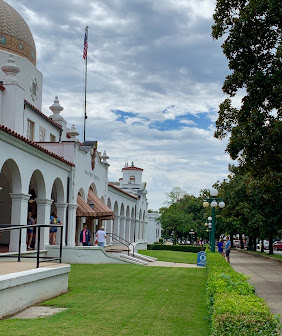
Driving into Arkansas and stopping at Hot Springs National Park, 
where we spend a day exploring the town and park, 
and relaxing at a wonderfully funky motel.

Day 6:

Followed Interstate 40 from Albuquerque to Asheville, NC. 
Stressful driving to say the least; dodging long haul trucks all the way.  
Above, driving along I-40 in the Cookeville, TN, area. 

Days 7, 8 and 9: 

Visiting with Jim's sister in Asheville, NC. Visited the Biltmore gardens, hiked to waterfalls at Dupont State Park, and spent time doing absolutely nothing at our Airbnb rental, a gem of a cottage surrounded by flower gardens and farm animals. 

Day 10: 

Taking a break from driving at the Peak of Otters National Park Lodge 
along the Blue Ridge Parkway.

Day 12: 

Crossing the Potomac by ferry from Virginia into Maryland.

Arrived!  

What a welcome we found! 

A poster drawn by all four granddaughters and a welcome basket with goodies 
(and Covid-19 essentials) to keep us going for a bit in an empty apartment.


Monday, October 26, 2020

Flat Top Trail, Blue Ridge Parkway, VA, 9/6/2020

An hour and a half hike to Sharp Top says the sign above! It it took us almost two hours to reach the summit trudging along a steep trail, and stopping frequently to let faster hikers pass.   

Since the time of the early settlers, Sharp Top was believed the tallest summit in Virginia until better measurement showed there several higher tops, with Mount Rogers to the south now officially the highest in the state. 

Views of the lake, about half way up the hill. Notice the three long buildings along the lake? That's the Blue Ridge National Park lodge where we stayed for two nights on our way from Albuquerque to Columbia, MD.  A beautiful and restful refuge, except that it was Labor Day weekend and quite busy.   

There really is a large rock formation in the shape of a turtle.


 Our reward at the top: 360-degree views with Peak of Otters, the Shenandoah valley and Allegheny mountains to the west, and the Piedmont to the east.  

Total distance: 5.4 miles; elevation 1,417 ft. Max elevation: 3,868 ft.

Thursday, October 22, 2020

Dupont Forest, NC, 9/4/2020


On our cross country trip from Albuquerque to Columbia, MD, we stopped for a couple of days to visit Jim's sister in Asheville, NC.  She kindly took us to visit the manicured gardens of the Biltmore estate; in its end-of-summer prime. The next day, Jim and I drove south to the Dupont State Recreational Forest, known for its many lakes and waterfalls along the Little River. 

Historically, the forest was part of the Biltmore estate, before being bought by the state. Although some of us are not particularly interested with how the ultra rich live, occasionally those living on a grand scale have the foresight to be stewards of the land. This was the case with Vanderbilt, who hired landscape architect Frederick Olmsted (architect of Grand Central Park in NYC.)  Olmsted with forester Clifford Pinchot were the first to develop a forest management plan. This in turn, lead to the founding of the first school of forest management in the US. 

On a fun note, scenes of both The Last of the Mohicans and The Hunger Games were filmed here. 


Triple Falls


High Falls

Total distance: 5.4 miles; elevation 1,417 ft; time ~ 4 hours, 
including picnic lunch and multiple stops to admire the falls. 

Tuesday, September 15, 2020

Hot Springs National Park, Hot Spring, AR, 8/31/2020


After three stressful days of driving east from Albuquerque, we stopped for a day to explore Hot Springs National Park in Hot Springs, Arkansas.  What a find it was! Coming from the arid west, we wondered at the luscious green land and forests.  The town itself is but a shadow of its splendid past, once a thriving medicinal thermal hot springs town.  Above, the National Park visitor center, located in the historic Fordyce bathhouse.  Only a few bathhouses are still open.  Because of Covid-19, an appointment is needed to enjoy the baths and since we did not make a reservation ahead of time, we missed out. 


It is myth that the hot springs water is heated by volcano activity.  Instead, we were told, rainwater is carried down to a depth of 4,000 to 8,000 feet where it is heat by the extreme heat of the earth. It then makes its way back, piping hot, to the surface via cracks and pores in the mountain's rocks.  The whole process takes 4000 years!


 Every where we walked, there was evidence of disrepair, boarded up buildings, crumbling structures and neglected homes. But nature was resplendent with its greens and blue hues. Mosses and ferns everywhere.  

We thoroughly enjoyed our short visit here in spite of the downpours, walking the Grand Promenade, doing a bit of hiking, and climbing the water tower.


Patapsco CCC Remains trail, Patapsco State Park, MD, 10/23/24

 Our first hike with Senior Rangers organized by Maryland Dept of Natural Resources. Actually, the fifth outing, as we missed some, and some...