Tuesday, June 19, 2012

Pueblo Alto Trail, Chaco Culture National Historical Park, June 17, 2012


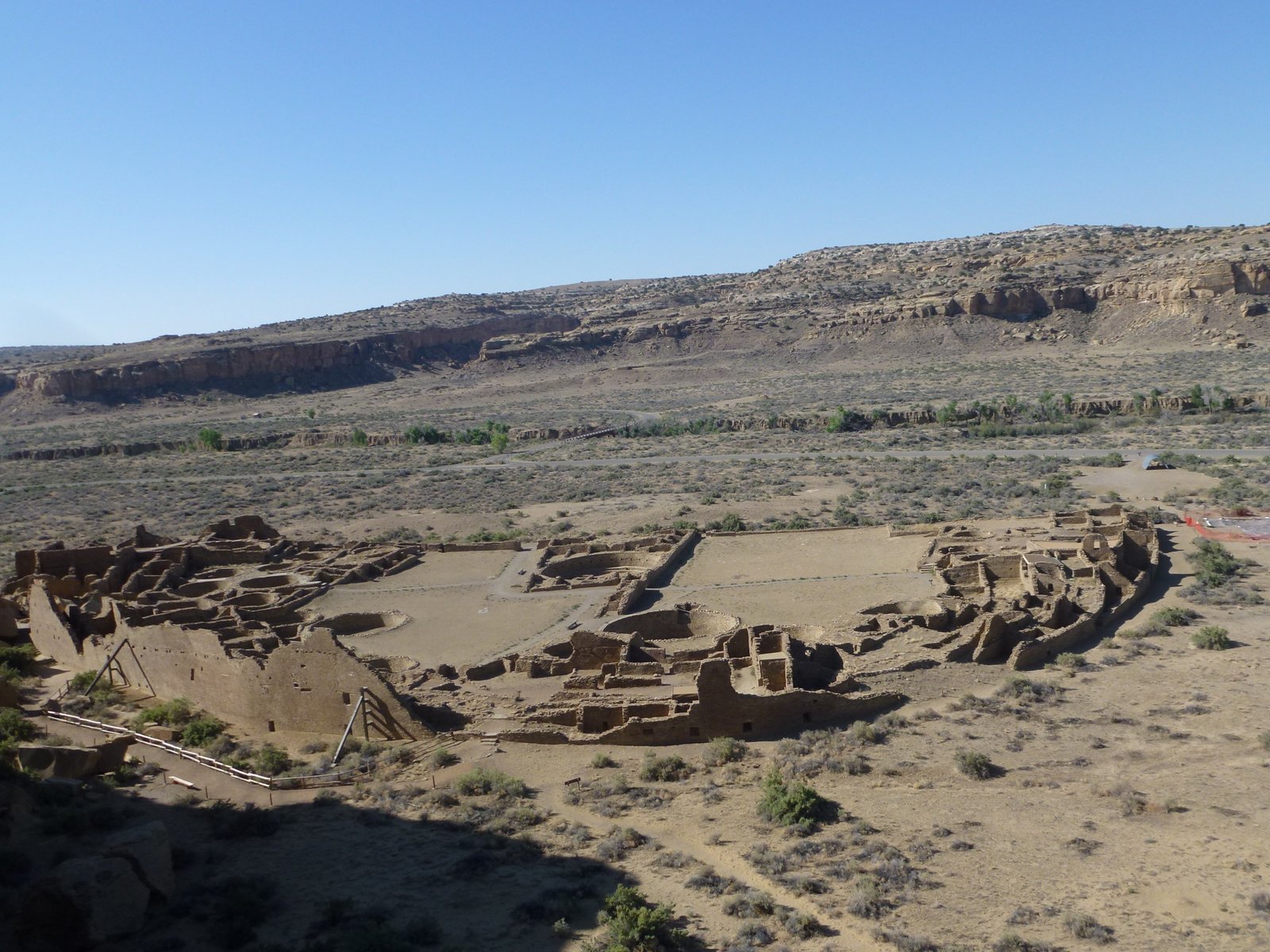
We spent last w.e. exploring Chaco Canyon. We toured the Great Houses on Saturday afternoon and settled on an early morning Sunday hike to Pueblo Alto, a Great House on top of the mesa, about 0.6 miles north (3 miles round trip.)  Above, Chetro Ketl.

First, we needed to climb up to the mesa.  A series of exposed steps led to a narrow passage up to the mesa.

There was a lot of talk about the summer soltice at Chaco Canyon. The ancestral Chacoans built all of the houses oriented to solar, lunar and cardinal directions.  A croud was expected in 4 days to observe the solstice and the many astronomical markings found in the park.  Above is my best attempt at giving you an idea of a summer solstice marking. Imagine the sun rays marking a particular point, a window or a petroglyph, at just a particular time during the solstice.  

View of Pueblo Bonito from the mesa.  
 

First view of Alto Nuevo.

Pueblo Alto.  Here is what a Great House looks like when it has not been recontructed.

Chaco remains a spiritual place to today's Pueble and Hopi people. Hiking the mesa and approaching the Great Houses,  I felt as if I was trespassing in a world that should not be treaded upon, if it wasn't  for the
crows bringing me back to reality.
Posted by Picasa

Friday, June 15, 2012

Arches National Park, Utah, May 25, 2012


We arrived at Arches National Park late in the afternoon of one of the busiest w.e. of the year only to find out we did not have a campsite reserved.  In addition, the visitor center warned against 60 mile an hour winds, not exactly ideal camping weather.   We decided to explore Moab and find a place that would give us a roof over our heads. After settling in for the night (and cooking dinner in the room's microwave), we went back to the park to enjoy the cooler evening weather and the sunset.  The pictures are blurry because of the sand being whipped up by the wind.

The Park has more than 2,500 arches, formed by running water over eons of years. Above, North Window and South Window.

Walking up to Double Arch.
 

One could call the park nature's art, a place that inspires contemplation, reflection and self-expression.
Posted by Picasa

Colorado National Monument, CO, Cont'd, May 27, 2012


Last hike of the day: Devils Kitchen Trail, 1.5 miles.  We guessed that the name is a reference to the intense heat of the region.  The trail started down a wash and up to a slickrock bench.

Steps carved into the sandstone led up to a natural stone room.
 
Posted by Picasa

Colorado National Monument, CO, Cont'd May 27, 2012


Next short hike, the Coke Ovens Trail, 0.5 miles.  The trail descends to an overlook above the Coke Ovens, a reference to the resemblance with iron ore ovens used in the early mining days.
 
 
Posted by Picasa

Colorado National Monument, CO, May 27, 2012


Unable to stay at Arches National Park because of the high winds, we decided to try our luck by driving east. We settled in Fruita, CO, next to the little visited Colorado National Monument. By Sunday morning the winds had quietened and visibility was much improved. We started the day with a short hike along the canyon rim.
 

Yes, the cliffs are really that sheer.  Just standing a few feet from the edge made me quizy. 


Independence Rock, the largest free standing rock in the park, stands 450 feet tall. It is a favorite of rock climbers and a tradition to climb it, you guessed it, on the 4th of July. 

Posted by Picasa

Tuesday, June 12, 2012

Hovenweep National Monument, Colorado/Utah, 5-25-12


We started our 5-day Memorial Day w.e. with a visit Hovenweep National Monument, a few miles north of the Four Corners area on the Colorado-Utah border. A path took us along the rim of the Cajon Mesa canyon, into it and passed the many Puebloan ancestral homes.  The development flourished between 1100 and 1300 AD.  By the 1200s prolonged droughts drove the people to the Rio Grande valley in New Mexico and the Hopi mesas of Arizona.

Stronghold House

Hovenweep House

Square Tower

The uniqueness of Hovenweep is that it has not been excavated as had Mesa Verde and Chaco Canyon.  The building building have been structurally reinforced in places but not rebuilt.

Twin Towers

View of Square Tower in the middle and Hovenweep Castle to the right.

Hovenweep Castle


Boulder House

Every site in the campground had a covered eating area, making it possible to have meals  protected from the sun. The shade, combined with the great views, the fabulous starry sky at night, and the complete silence made it one of our favorite campgrounds.  Well worth the long drive.
Posted by Picasa

Montgomery Pass Trail, Cache la Poudre Canyon, CO, 3-11-12


Last snowshoe hike of the season. This trail started at 9,987 ft and climbed steadily thru a spruce forest for about 2 miles to the pass at 10,998 ft. The trail was icy, which kept most hikers away.  We met one couple on X-country skis and teen snowboarders with snowshoes on feet and snowboards and helmet on back. Neither planned on going to the pass but took a side trail to an area called "the Bowls," a region popular with back country skiers (and famous for its avalanches).

We snowshoed past a jeep trail along side Montgomery Creek and up to the ruins of settler Tom Montgomery's cabin.  Except we did not see either because of the snow. 

Made it! Stunning views awaited us a the pass. Walking the last 500 yards up the pass felt like walking on top of the world...

Views to the west and north. We would love to do this hike in early summer when the alpine flowers are in bloom and follow the south ridge to Diamond Peak, 1/5 miles away.
Posted by Picasa

Wincopin trail, Savage Park, MD, 4/16/2024

Midweek afternoon stroll along the Wincopin red trail in the company of Master Gardener Ann Coran, who invited us on a spring wildflower hun...