We joined a Asheville Unitarian Church group on a hike to the historic Carl Sandburg home. Carl Sandburg moved to this home near Flat Rock, NC, at age 62 and wrote several of his most well know works here, including his biography of Lincoln.
Approach to the house up on the hill.
Along the hiking path up to Glassy Mountain, mosses and more mosses....
This is Glassy Mountain, a large expanse of granite rock with great views, used as the local sunning beach.
Don't see this in New Mexico: violets.
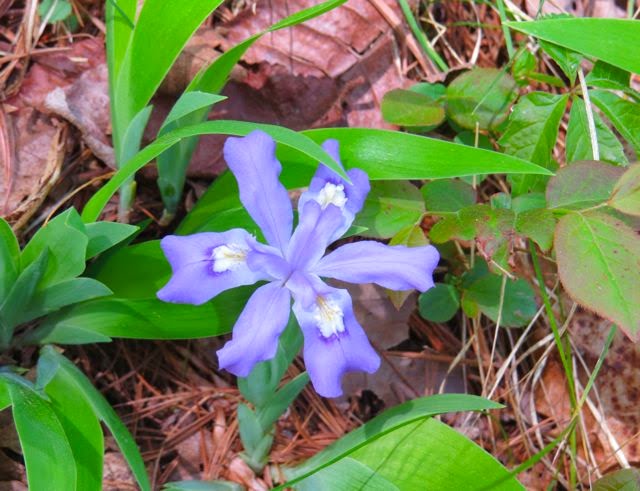
Another flower we don't have in NM: a dwarf, crested, bearded iris.
Can't go hiking on the East Coast in the Spring without getting at least one picture of the dogwoods in bloom.
Carl Sandburg wrote, and his wife kept champion goats. She meticulously recorded how much milk the goats produced. The record: 2 gallons per day! We were in luck visiting her Connemara Goat Dairy Farm: baby goats gallivanting in the meadows.
A great day combining history and hiking.
Glassy Mountain: ~2 miles round trip, elevation ~500 feet.
Wednesday, April 30, 2014
Embudo Trail, Sandia Mountains, NM, 4/20/14
Normally, this is a waterfall. Water from the Embudo trail spring emerges and flows over the concrete retaining wall, creating a pond at its base. We last hiked here maybe two years ago and there was plenty of water. This is what we found on this spring day.... just a trickle.
Hiking out of the narrow canyon, we reached a burned zone. Although we live in Albuquerque, we were not aware that a wildfire had devastated this area.
City views on a not so clear day....
In spite of the lack of moisture, the wildflowers were at their best.
Embudo trail: 6.4 miles round trip, elevation ~1680 feet.
Wednesday, April 9, 2014
Carpenter Peak, Roxborough Park, CO, 3/23/14
Want to see beautiful rock formations, panoramic views of Denver and the Front Range, and wildlife? This is the hike. We had not started our 6.4 mile hike when we met a herd of deer along the road.
This moderate hike starts at the visitor center and follows Willow Creek Loop to South Rim trail. Carpenter trail starts with a series of easy uphill switchbacks and then levels out before reaching a bit of a scramble to reach the top.
View before reaching Carpenter trail. It was cold and snowy the previous day - the white patches on the picture above are the remainder of yesterday's snow. Our challenge today: mud on the trail.
We visited Roxborough Park during one of our first trips to Denver. We revisited because we were enchanted by this wonderful place. For pictures of that earlier hike, check the blog "Denver Hike" posted in February 2009.
This moderate hike starts at the visitor center and follows Willow Creek Loop to South Rim trail. Carpenter trail starts with a series of easy uphill switchbacks and then levels out before reaching a bit of a scramble to reach the top.
View before reaching Carpenter trail. It was cold and snowy the previous day - the white patches on the picture above are the remainder of yesterday's snow. Our challenge today: mud on the trail.
![]() |
Views to the north-west from the peak. I used my new camera with a 50x zoom. The snowy peaks were actually a sliver of white with the naked eye. |
We visited Roxborough Park during one of our first trips to Denver. We revisited because we were enchanted by this wonderful place. For pictures of that earlier hike, check the blog "Denver Hike" posted in February 2009.
Monday, February 10, 2014
Fletcher Trail, Sandia Mountains, 2/9/14
We lucked out on this hike! The whole area is closed to hikers from March 1 to August 15 to protect wildlife.
Fletcher trail, 4 miles round trip, starts in a stream bed about 1/4 mile up Piedra Lisa trail. It follows the stream north for about 1/2 mile, then heads into the woods paralleling the stream bed. The turnoff is easy to miss. See 4 pictures below - I decided on the way back to take a picture as a reminder :)
After another 1/3 of a mile or so, the trail crosses the stream bed and heads east straight up a ridge. The elevation of this hike was ~1200 feet, and all of it was trekking up the ridge.
Disappointing views from the city from the top of ridge - hazy day.
After topping the ridge, the trail heads south and ends at the foot of the UNM Spire, a favorite of climbers.
Turn off from stream bed. Yes, it did have a cairn.
Almost back at the car we turned around to a great view of both the UNM Spire and the Prow.
Thursday, January 30, 2014
Juan Tabo Canyon Trail #4, Sandia Mountains, 1/25/14
A day of exploration! First time hiking trail #2, #2B and the southern section of trail #4. Finding the trail head was challenging. No markers. We hiked almost to the end of Trail 2 before I was able to admit that, yes, we were on the correct trail. Trail #2 ended in a residential area and was barricaded. Turning back, we could see the canyon cutting into the mountain where the southern end of trail #4 ends.
Trail #4 started in a wide riverbed...
that, entering the canyon, gradually got narrower...
and narrower. Water flows for the second half of tail #4 and we hopped our way back and forth following the stream bed.
End of the trail: the boundary with the Sandia Pueblo grounds. This is not a well known trail. Only locals seem to know it. We were alone most of the time which gave us the feeling of being completely separated from civilization, although the city was right over the hill and city noises were audible from time to time.
Tree Spring Trail, Sandia Mountains, 1/5/14
First hike of 2014. Looking for snow, we picked a hike on the east side of the mountain. We donned our yak tracks and started out on this trail covered with more ice than snow, got side tracked, hiked part of Oso Corredor trail and.... ended up back to the trail head.
Got to enjoy some great eastern views once we found the correct trail climbing up the mountain.
After 2 miles, we reached the Sandia Mountain Wilderness boundary. The Tree Spring trails merges with the 10K Loop and the Crest trails at this intersection. Just 200 feet west, we found an outlook with spectacular views of both the mountain and the city.
Saturday, January 4, 2014
Ventana Canyon to Maiden Pools, Tucson, AZ, 12/30/13
We set out to hike Mount Lemmon about mid-morning but were turned away because of snow and ice on the trail. That left us the option of finding a (half-day) hike at lower elevation. We explored Sabino Canyon during our previous stay in Tucson about five years ago and so settled on much less visited Ventana Canyon. Until recently access to the canyon was difficult because permission was needed to cross private land. A one-mile easement was built by the county opening up the canyon to all.
Subscribe to:
Posts (Atom)
Patapsco CCC Remains trail, Patapsco State Park, MD, 10/23/24
Our first hike with Senior Rangers organized by Maryland Dept of Natural Resources. Actually, the fifth outing, as we missed some, and some...

-
Panoramic photo of approach to Dripping Springs Natural Area with Organ Mountains in background. A thriving resort in the early 190...
-
Missed today's Wednesday Mountain Club snowshoe and instead set out for a hike in the foothills, from the Menaul trailhead to some wa...
-
First of our micro hikes in the South Dakota Black Hills while visiting with Jim's grandson, Micheal. Above the Mount Rushmore rock car...