Tuesday, April 16, 2019

Havasu Falls, Havasupai Reservation, Grand Canyon, AZ, 4/8/19


Off to day of exploring the Havasu Falls.  There we are all taking pictures of the Navajo Falls, the first on of several major falls in the area. 


Havasu Creek runs about 12-13 miles from the village thru the canyon to join the Colorado river.


The campground runs for at least 2 miles all along Havasu Creek and provides space for up to 600 people.  A villager told us that reservations are usually limited to 400 per nite to limit the impact on the land.  It was one of the most beautiful campgrounds I have ever seen. 


Havasu Falls


Brave souls, bathing in ice cold waters.


After Havasu Falls came Mooney Falls, accessible only via a tunnel, hand holds, chains, ropes and ladders.  I took one look at the people carefully inching their way down the cliff and decided that was not for me. 


Thursday, April 11, 2019

Hualapai Hilltop to Supai Village, Grand Canyon, AZ, 4/7/19

Walked 8 miles down to Supai Village, with a drop of ~1600 feet in the first 1.5 miles.  The village is reached by foot, on horseback, or via helicopter.  Two of our group chose to ride the helicopter in. We could hear the choppers flying back and forth between the hilltop and the village all during the descent.  Hot day again that got hotter as we lost elevation.  We carried a daypack only, as the horses and mules brought down our overnight bags. 


Finally, at about the 7-mile mark we crossed Havasu Creek and reached the village soon after, a true oasis in the dessert. Note the blue-green color of the water, for which the area is known.  

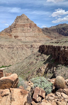
Tonto Mesa Trail, AZ, 4/6/19

First of four hikes with Road Scolar trip to Havasu Falls.  Climbed up to the mesa in Peach Springs Canyon in the western Grand Canyon and followed it up and down for about 3.6 miles round trip.  Challenging hike: hot day and uneven, rough trail requiring a fair amount of scrambling.


Diamond Peak across the canyon.  The story goes that the mountain got its name after a speculator hid diamond around the base of the peak and then sold parcels to miners.  Didn't take long until someone figured out that diamonds do not come out of the ground all polished. 

A choya forest. Best navigated with care. Removing the spines from your hands, ankles and boots requires tweezers and pliers!

Drove about 1.5 miles down to the Colorado river after the hike. 

Thursday, April 4, 2019

Golden Open Space, NM, 4/2/19


Wednesday NM Mountain Club outing at the City of Albuquerque Golden Open Space, an area used mostly by mountain bikers and horseback riders.  Unexpectedly not located in town but east of the Sandia Mountains.  


Someone in our group said, "these horses do not look wild; they much too well groomed!"


The weather cooperated until the very end of our almost 7-mile hike when we got some light rain and hail. 

Patapsco CCC Remains trail, Patapsco State Park, MD, 10/23/24

 Our first hike with Senior Rangers organized by Maryland Dept of Natural Resources. Actually, the fifth outing, as we missed some, and some...